intersectgeoquad
Intersection of two latitude-longitude quadrangles
Syntax
[latlim, lonlim] = intersectgeoquad(latlim1, lonlim1,
latlim2, lonlim2)
Description
[latlim, lonlim] = intersectgeoquad(latlim1, lonlim1,
latlim2, lonlim2)
computes the intersection of the quadrangle
defined by the latitude and longitude limits latlim1 and lonlim1,
with the quadrangle defined by the latitude and longitude limits latlim2 and lonlim2. latlim1 and latlim2 are
two-element vectors of the form [southern-limit northern-limit].
Likewise, lonlim1 and lonlim2 are
two-element vectors of the form [western-limit eastern-limit].
All input and output angles are in units of degrees. The intersection
results are given in the output arrays latlim and lonlim.
Given an arbitrary pair of input quadrangles, there are three possible
results:
The quadrangles fail to intersect. In this case, both
latlimandlonlimare empty arrays.The intersection consists of a single quadrangle. In this case,
latlim(likelatlim1andlatlim2) is a two-element vector that has the form[southern-limit northern-limit], wheresouthern-limitandnorthern-limitrepresent scalar values.lonlim(likelonlim1andlonlim2), is a two-element vector that has the form[western-limit eastern-limit], with a pair of scalar limits.The intersection consists of a pair of quadrangles. This can happen when longitudes wrap around such that the eastern end of one quadrangle overlaps the western end of the other and vice versa. For example, if
lonlim1 = [-90 90]andlonlim2 = [45 -45], there are two intervals of overlap:[-90 -45]and[45 90]. These limits are returned inlonlimin separate rows, forming a 2-by-2 array. In our example (assuming that the latitude limits overlap),lonlimwould equal[-90 -45; 45 90]. It still has the form[western-limit eastern-limit], butwestern-limitandeastern-limitare 2-by-1 rather than scalar. The two output quadrangles have the same latitude limits, but these are replicated so thatlatlimis also 2-by-2.To continue the example, if
latlim1 = [0 30]andlatlim2 = [20 50],latlimequals[20 30; 20 30]. The form is still[southern-limit northern-limit], but in this casesouthern-limitandnorthern-limitare 2-by-1.
Examples
Nonintersecting quadrangles:
[latlim, lonlim] = intersectgeoquad( ...
                   [-40 -60], [-180 180], [40 60], [-180 180])
latlim =
[]
lonlim =
[]Intersection is a single quadrangle:
[latlim, lonlim] = intersectgeoquad( ...
                   [-40 60], [-120 45], [-60 40], [160 -75])
latlim = -40 40 lonlim = -120 -75
Intersection is a pair of quadrangles:
[latlim, lonlim] = intersectgeoquad( ...
                   [-30 90],[-10 -170],[-90 30],[170 10])
latlim = -30 30 -30 30 lonlim = -10 10 170 -170
Inputs and output fully encircle the planet:
[latlim, lonlim] = intersectgeoquad( ...
                   [-30 90],[-180 180],[-90 30],[0 360])
latlim = -30 30 lonlim = -180 180
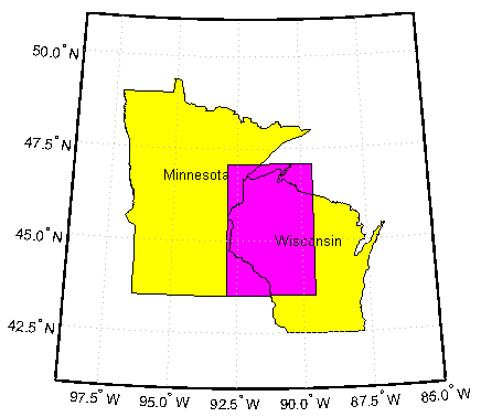
Find and map the intersection of the bounding boxes of adjoining US states:
usamap({'Minnesota','Wisconsin'})
S = shaperead('usastatehi','UseGeoCoords',true,'Selector',...
    {@(name) any(strcmp(name,{'Minnesota','Wisconsin'})), 'Name'});
geoshow(S, 'FaceColor', 'y')
textm([S.LabelLat], [S.LabelLon], {S.Name},...
    'HorizontalAlignment', 'center')
latlimMN = S(1).BoundingBox(:,2)';
lonlimMN = S(1).BoundingBox(:,1)';
latlimWI = S(2).BoundingBox(:,2)';
lonlimWI = S(2).BoundingBox(:,1)';
[latlim lonlim] = ...
    intersectgeoquad(latlimMN, lonlimMN, latlimWI, lonlimWI);
geoshow(latlim([1 2 2 1 1]), lonlim([1 1 2 2 1]), ...
    'DisplayType','polygon','FaceColor','m')
Tips
latlim1 and latlim2 should
normally be given in order of increasing numerical value. No error
will result if, for example, latlim1(2) < latlim1(1),
but the outputs will both be empty arrays.
No such restriction applies to lonlim1 and lonlim2.
The first element is always interpreted as the western limit, even
if it exceeds the second element (the eastern limit). Furthermore, intersectgeoquad correctly
handles whatever longitude-wrapping convention may have been applied
to lonlim1 and lonlim2.
In terms of output, intersectgeoquad wraps lonlim such
that all elements fall in the closed interval [-180 180].
This means that if (one of) the output quadrangle(s) crosses the 180°
meridian, its western limit exceeds its eastern limit. The result
would be such that
lonlim(2) < lonlim(1)
lonlim(k,2) < lonlim(k,1)
k equals
1 or 2 if the intersection comprises a pair of quadrangles.If abs(diff(lonlim1)) or abs(diff(lonlim2)) equals 360,
its quadrangle is interpreted as a latitudinal zone that fully encircles
the planet, bounded only by one parallel on the south and another
parallel on the north. If two such quadrangles intersect, lonlim is
set to [-180 180].
If you want to display geographic quadrangles generated by this
function or any other which are more than one or two degrees in extent,
they may not follow curved meridians and parallels very well. The
degree of departure depends on the extent of the quadrangle, the map
projection, and the map scale. In such cases, you can interpolate
intermediate vertices along quadrangle edges with the outlinegeoquad function.
Version History
Introduced in R2008a