local2latlon
Convert local Cartesian coordinates to geographic coordinates
Description
[
converts point locations given by lat,lon,alt] = local2latlon(xEast,yNorth,zUp,origin)xEast, yNorth,
and zUp from local Cartesian coordinates to geographic coordinates
returned as lat, lon, and
alt. origin specifies the anchor of the local
coordinate system as a three-element vector of the form
[latOrigin,lonOrigin,altOrigin].
Local coordinates xEast, yNorth, and
zUp align with the east, north, and up directions, respectively.
alt and altOrigin are altitudes as typically
returned by GPS sensors.
Examples
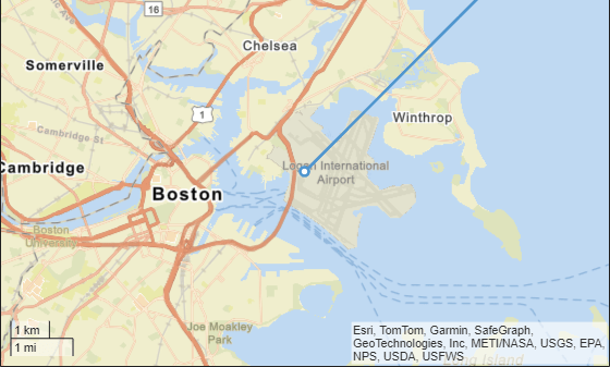
Establish an anchor point in the geographic coordinate system. These latitude and longitude coordinates specify Boston, MA.
origin = [42.3648, -71.0214, 10.0];
Generate local route in Cartesian coordinates, x, y, and z.
z = zeros(1,101);    % maintain height of 0 m
x = 0:1000:100000;   % 100 km in 1 km increments
y = x;               % move 100 km northeast
Convert the local route coordinates to geographic coordinates, latitude and longitude.
[lat,lon] = local2latlon(x,y,z,origin);
Visualize the route on a map.
zoomLevel = 12;
player = geoplayer(lat(1),lon(1),zoomLevel);
plotRoute(player,lat,lon);
Input Arguments
Output Arguments
Tips
The latitude and longitude of the geographic coordinate system use the WGS84 standard that is commonly used by GPS receivers.
This function defines altitude as the height, in meters, above the WGS84 reference ellipsoid.
Some GPS receivers use standards other than WGS84. Conversions using other ellipsoids are available in the Mapping Toolbox. This function addresses the most common conversion between geographic locations and Cartesian coordinates used by the on-board sensors of a vehicle.